| ↑ TAHS Home | |
| ← Part I. | Part III. → |
The 1847 geological survey trip of J. G. Norwood, MD – Part II
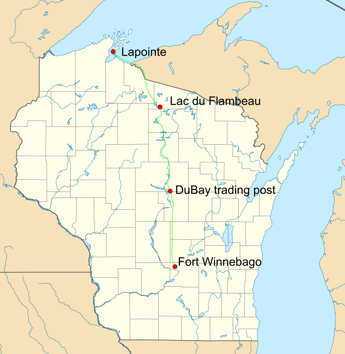
September 27 – October 2: Lac du Flambeau to the Wisconsin River via Trout Lake
| Table of Contents | |
|---|---|
| Introduction | |
| Part I. | La Pointe to Lac du Flambeau |
| Part II. | Lac du Flambeau to Wisconsin River |
| Part III. | Wisconsin River to Grandfather (includes vicinity of modern Tomahawk) |
| Part IV. | Grandfather to Grand Rapids (modern Wisconsin Rapids) |
| Part V. | Grand Rapids to Prairie du Chien |
September 27. – From this point we had to find our way to the head waters of Wisconsin river, without a guide, or the slightest knowledge of the country through which we were to pass. The aid afforded by Mr. Nicollet's map not being of a reliable character for this region, I sent Baptist to the Indian village to procure such information as would enable us to reach Vieux Desert lake, or its vicinity, with as little delay as possible. While be was gone, an Indian whom I knew very well, having met him at Madeline island in July, and afterwards at Fond du Lac, came to our camp; and from him we learned that there are three routes from this lake to Wisconsin river. One of them is by a chain of lakes south of this point, and leading into the Little Wisconsin through White Squirrel creek; another by way of Leech, Kewaykwodo and Swamp lakes; and a third through a series of lakes towards the head waters of Manidowish river, and thence, via Trout lake and a series of small lakes, to Vieux Desert lake; which last route might be changed about twenty miles southwest of Vieux Desert, so as to enable us to strike the Wisconsin ten miles south of that lake. The first route is the one usually followed by the traders in their journeys from the posts on the Wisconsin to La Pointe. As it would, however, lead us into the Wisconsin too far south to subserve the purposes of the survey, we decided upon the route by Trout lake.
Finding "Puzigwingis," the name of the Indian alluded to, intelligent, and willing to impart any information we might desire with regard to the country, in order to test his abilities I got him to draw a map of our route from Lake Superior to this place, and finding it agreed in every respect with our own observations, I determined to remain in camp to-day, for the purpose of procuring from him an outline map of the surrounding country, and particularly of the part to be traversed by us. He spent about half the day in executing our wishes, and so far as I am able to judge of the whole by the part that fell under my immediate observation, it is quite as accurate as it could possibly have been made by any one having no knowledge of the principles upon which maps are constructed. The only valuable purpose which it can subserve, however, is that of a guide through a very intricate wilderness, until accurate surveys are made; but even that is a desideratum in a country where there is such a multitude of lakes and impassable swamps to impede and turn one aside from a course which might otherwise be followed from a knowledge of the general bearing of known points.
Lac du Flambeau is the largest body of water we have seen in this region. It is exceedingly irregular Tn its outline, resembling rather an assemblage of several small lakes, united at one point by short narrow channels. It has a number of thickly wooded islands dotting its surface. The shores recede with a gentle slope, to the height of twenty and thirty feet, and are covered at some points with bushes and grass, and by a dense forest at others. The soil, like that in the neighbourhood of Turtle lake, is a light sandy loam; and, judging from its general appearance, would hardly attract the attention of a cultivator. The Indians, however, who have a village on one of its shores, raise excellent potatoes, better indeed, than are usually grown, with all the aids of cultivation, in the valley of the Ohio. The arm of the lake, near which we encamped, is called by the Indians, Pokegoma; a name given to any lake connected with another, or with a running stream, by a very short outlet.
In this entry, Norwood confirms a very important general fact that some historians have gotten wrong, which is that the main north-south route, from the settlements in the south to Lac du Flambeau and Lapointe in the north, was via the Tomahawk River, then called the Little Wisconsin. Modern-day Tomahawk was known as the Forks of the Wisconsin, or simply The Forks, prior to the development of the dam and mills in that town in 1886. < p> There was also a somewhat lesser-used trade route up the Wisconsin, to Pelican Station (modern Rhinelander). The Forks were thus a general intersection, and from early days attracted settlers, Indian and non-Indian. There was a substantial Indian village at the mouth of Skanawan Creek, and later a tavern/station was built there known as Gilbert's Station.
September 28. – The Pokegoma arm of Lac du Flambeau, which we crossed this morning, is about three and a half miles long by half a mile in width. It abounds with fine fish, which the Indians take in great numbers in gill nets and with the spear. From the northeast shore of this lake a portage of half a mile, over sand hills, covered with small pines and elevated about thirty feet above the general level of the small lakes, leads to Lake Wepetangok, which we crossed in a high wind. This lake is about two miles long, and our course across it was northeast to a small channel, four feet wide and eight yards long, which led us into another small lake three-fourths of a mile long and half a mile wide, which we crossed northeast to a portage of one mile in length, leading to Mashkegwagoma lake. This portage passed over hills of the same character as those seen in the morning.
We waited sometime on the shore of this lake for the wind to subside, and at noon started across. By the time we had made two-thirds of the passage the wind increased to a perfect gale, and wave after wave, which ran almost as high as I have ever seen them in Lake Superior, broke over our canoe until it was more than half full of water and in momentary danger of sinking. By great exertions the men succeeded in reaching the borders of a small island, and we dragged the canoe into a marsh. Everything was thoroughly soaked, with the exception of my note books, which, very fortunately, were secured on my person. A fire was built in a spruce thicket, the highest part of the island, and we set about drying our persons, clothes, maps, and instruments. As the wind continued high all the afternoon we were forced to camp on the island. The lake is about two and a half miles long and one mile and a ' half wide, a very small sheet of water to afford so heavy a swell. Our misfortune is to be attributed, however, more to the size of our canoe than to the roughness of the lake.
September 29. – Crossed to the main shore, and made a portage of, a mile and a half, to the Chippewa or Manidowish river. The trail, for nearly the whole distance, leads through swamps flooded with water almost ice cold. The river at this point is about forty feet wide, winding to the northwest through marshes like the one just passed.
Had it not been desirable to visit Lac du Flambeau, we might have reached this point by ascending the river from "Six Pause portage," through "Cross" and other small lakes; and this was the route pursued by Mr. A. B. Gray and party in 1846, as I have since learned. I knew nothing of the route, however, until I reached Lac du Flambeau, when I learned it from Puzigwingis. It is the one commonly followed by the Vieux Desert and Trout Lake Indians in passing from their villages to La Pointe, and is in every respect preferable to the one pursued by us, for persons wishing to pass from the head of Wisconsin river to the neighborhood of Montreal and Bad rivers or to any point northwest of Lac du Flambeau.
While the men were sent up the river with the canoe, Mr. Gurley and myself took the trail for Trout Lake. The portage is an excellent one, about four miles and a half long, and passes for some distance over a sandy plain supporting a few scattering pines. The surface of the ground is literally covered with the wintergreen, and the general features of the landscape resemble very much those seen in the neighbourhood of Lac Courte Oreille. About half way on the portage, we ascended a hill of drift, between forty and fifty feet in height, with a great number of crystalline boulders and a few large fragments of sandstone scattered over it. From the top of this hill a range of highlands were seen in our rear, distant eight or ten miles, bearing northeast and southwest. From their position and course, we judged them to be a continuation of the range seen in ascending Lac du Flambeau River. The drift continues on the Trout Lake.
About one mile before reaching the lake, the river becomes very shallow, and is obstructed by boulders as to require a portage to be made. There is an Indian village at Trout Lake, which is only occupied, however, during the summer and fall months. They have gardens for corn and potatoes at this place, though their principal dependence for food is upon the lake, which yields them a plentiful supply of fine fish. We received from an Indian here a lot of very fine potatoes, a most acceptable present, as more than two-thirds of the provisions we had brought from La Pointe were consumed, and we had not yet performed more than one-third of our journey.
Trout Lake is seven or eight miles long by about four miles wide, and contains a number of small islands. It is surrounded by drift hills, from twenty-five to forty feet high, supporting a sparse growth of small pines and birch. Our course across it was northeast, to a trail leading to Lower Rock Lake. We encamped on the trail, a short distance from the lake. At six o'clock, p. m., the thermometer stood at 31 Fah., and our tent and baggage, which had got wet in crossing the lake, froze.
September 30. – Ice formed one-fourth of an inch thick last night. The portage between Trout and Lower Rock Lakes is about two miles and a quarter in length, and runs along the base of drift hills. These lakes are connected by a small stream, not navigable for canoes. The Lower Lake is about half a mile in diameter. A portage of three hundred yards leads to Upper Rock Lake, which is one mile in its largest diameter, and contains a number of small islands. These lakes are also connected by a small stream. They derive their name from the immense number of boulders which line their shores, and show themselves above the water in the shallow parts. The islands, in the upper one, are made up almost entirely of boulders, with a thin soil covering them, and supporting a few small trees. Some very large masses of syenitic granite, hornblende, and greenstone, with smaller ones of amygdaloid, were seen near the east end.
We bad great difficulty in finding the portage from this lake. It begins on the northeast shore, and is about two and a half miles long. Its course is nearly due east, passing a good part of the distance along the margins of cranberry marshes. Three small ponds were passed in the first two miles. They are connected by a small stream flowing into Upper Rock lake, and which is navigable for canoes up to the second pond. From this point a portage of everything has to be made to Lower White Elk lake. The country passed over yesterday and to-day is made up of drift hills, from twenty to sixty feet high. The sand is white and coarse, while the boulders, which are disseminated through the upper part, were derived almost entirely from granitic rocks. The soil is thin, but supports a growth of small pine, poplar, birch, spruce, hemlock, fir, a few oaks, and some bass wood; the swamps, as usual, being filled with tamerack, or, where that is wanting, over run with cranberry bushes.
Lower White Elk lake, where we camped, is about three-quarters of a mile long, and a quarter of a mile wide. Here we found a number of deserted wigwams and the remains of a garden. The lake affords great numbers of fish, and the quantity of their remains scattered around shows they are the principal article of food among the Indians who occasionally inhabit it.
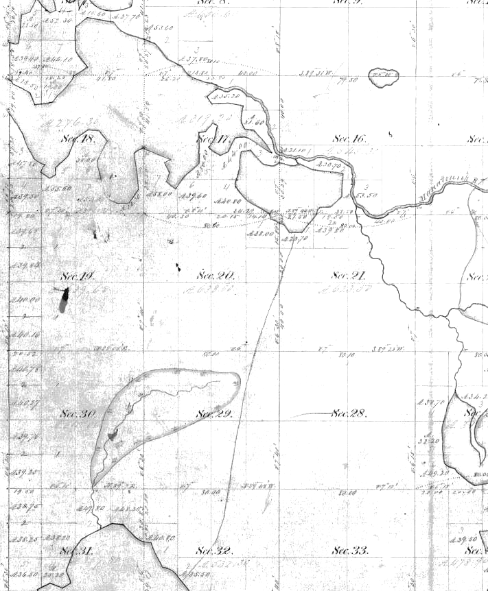
Trout Lake, Boulder Lake portage. Norwood's September 30th journal entry is one of the most confusing sections in his report. In the 1865 survey map on the left, a portage trail is shown connecting Trout Lake (lower part of the map) with a lake now called Little Rice Lake. Boulder Lake is at the top of the map. There is little doubt that Norwood followed this trail and Boulder Lake is probably what Norwood referred to as Lower Rock Lake.
What he needed to do was get to the Manitowish River, which flows from east to west into Boulder Lake at this point, and he may have gone in a circle and gotten confused, rather than heading straight north across Little Rice Lake (his Upper Rock Lake) to intersect it.
October 1. – A very heavy frost this morning; the thermometer standing at 25 Fah. at half past six o'clock. We crossed first White Elk lake, and, by a stream twenty feet wide and a quarter of a mile long, passed into second White Elk lake, which is about two miles long and one mile wide. From this we passed into third White Elk lake, by a river ten yards wide, and three hundred yards long. This lake is nearly circular, and about one mile in diameter. It is very shallow, not haying a depth of more than three feet at any point, with a mud bottom. We noticed here a phenomenon, not hitherto observed in any of the great number of small lakes we have seen in the territory. The whole surface of the lake was covered with bubbles of light carburetted hydrogen gas, which was constantly ascending from the bottom.
From this lake, a portage of a quarter of a mile brought us to the fourth White Elk lake. The portage leads due east, over drift, covered with a better soil than any met with for several days past. It supports a tolerably good growth of sugar maple, birch, oak, poplar, and a few pines. This lake is a beautiful sheet of water, about one mile long and three-fourths of a mile wide. The bottom is covered with pebbles and the shores with boulders, some of which are very large; one of them being over fifty feet in circumference. This is the source of the east or Manidowish branch of Chippewa river; all the lakes and streams beyond this point, which send their waters to the Mississippi, being tributaries of the Wisconsin. The hills, bounding the north and east shores, are about one hundred and fifty feet high, and are composed of white sand, with occasional boulders scattered over the surface. Almost all the boulders seen, for the last three days, were granitic and small. Today, however, at Fourth Elk Lake, boulders of other rocks were numerous, and, from the size of some of them, I infer that the source from which they were derived is not very distant.
The portage to the head-waters of Wisconsin River starts due east from this lake. In about half a mile the trail divides, the left-hand branch leading directly to Vieux Desert Lake, the other to a small lake which discharges its waters into the Wisconsin, about ten miles in a direct line south of Vieux Desert. We determined to take the shortest route, principally on account of the little provisions we had remaining, and the certainty that they would be exhausted before we could reach any point where supplies could be had.
The portage is about six miles long, over a high, rolling pine country, which does not afford a drop of water, from the Upper White Elk Lake to within a quarter of a mile of the end of the portage, where a small stream, ten feet wide, from the northwest, crosses the path.
The high and broad strip of land which divides the waters of the Chippewa from those of the Wisconsin is made up of white sand, with small boulders thinly scattered over the surface. The pines with which it is covered are small, but very tall and straight, many of their trunks rising fifty or sixty feet without a branch. On some of the higher hills a great many small birch were seen; and in the vicinity of Muscle Lake the sugar maple began to appear.
October 2. – The ground was whitened by a heavy frost, and the atmosphere cool and bracing. Muscle Lake, upon which we began our voyage to the Mississippi, is about one mile long and rather more than half as broad. A small stream, about one hundred and fifty yards in length, led us into another lake, rather more than half a mile in diameter. It discharges its waters into the Wisconsin River, through a small creek, from one to five yards wide, running east. The creek is very shallow, very crooked, and much obstructed by drift wood, but without a rock of any description. Its whole course is through swamps, bordered by sand-banks covered with pine. The banks have quite a reddish appearance, although the sand in the bed of the river is white. The entire bed of the creek, in many places, is covered by several species of Unio.
At half-past twelve o'clock we entered Wisconsin River, which is twelve yards wide at the junction, and from three to four feet deep. Its course is south for several miles, but gradually changes to southwest, which was the prevailing course during most of the afternoon. We encamped about eighteen miles below the mouth of Muscle River, although in a direct line, probably, not more than six or seven miles, as the river is remarkably crooked. It is from ten to fifteen yards wide, and is occasionally obstructed by drift-wood. We did not see a rock or pebble of any kind, until just before reaching our camping-ground, when a solitary boulder showed itself; and, a few minutes afterwards, the shores were found lined with pebbles, washed out of the banks, which are composed of sand, and are from three to twenty feet high, and covered with pine, fir, and spruce, with a few aspens and small birch. The low grounds, which frequently intervene between the river and the high banks, support elm, and, where very low, tamerack in abundance. The margin of the water is overhung by alders and cranberry bushes. At one point the drift was seen resting on a bed of reddish-coloured indurated clay. The banks, where slides have taken place, present all the appearance of stratification, with a dip to the south greater than the fall of the river. A few first-rate and many second-rate pines were seen.
The lake and stream that Norwood refers to as Muscle Lake and Muscle River are Upper Buckatabon Lake and Buckatabon Creek. The portage trail from Fourth White Elk Lake that the expedition team followed is well-marked on the 1860s vintage survey plat maps. The lake levels of Upper and Lower Buckatabon Lakes have since been raised by a dam, and the "small stream, about one hundred and fifty yards in length" that Norwood refers to is now a wide channel.
| ← Part I. | Part III. → |