| ↑ TAHS Home | |
| Part I. → | |
The 1847 geological survey trip of J. G. Norwood, MD
© 2013 Jon G. Wurl and the Tomahawk Area Historical Society.
This copyright notice applies to all annotations as well as the page layout. Norwood's account is in the public domain.
| Table of Contents | |
|---|---|
| Introduction | |
| Part I. | La Pointe to Lac du Flambeau |
| Part II. | Lac du Flambeau to Wisconsin River |
| Part III. | Wisconsin River to Grandfather (includes vicinity of modern Tomahawk) |
| Part IV. | Grandfather to Grand Rapids (modern Wisconsin Rapids) |
| Part V. | Grand Rapids to Prairie du Chien |
Introduction
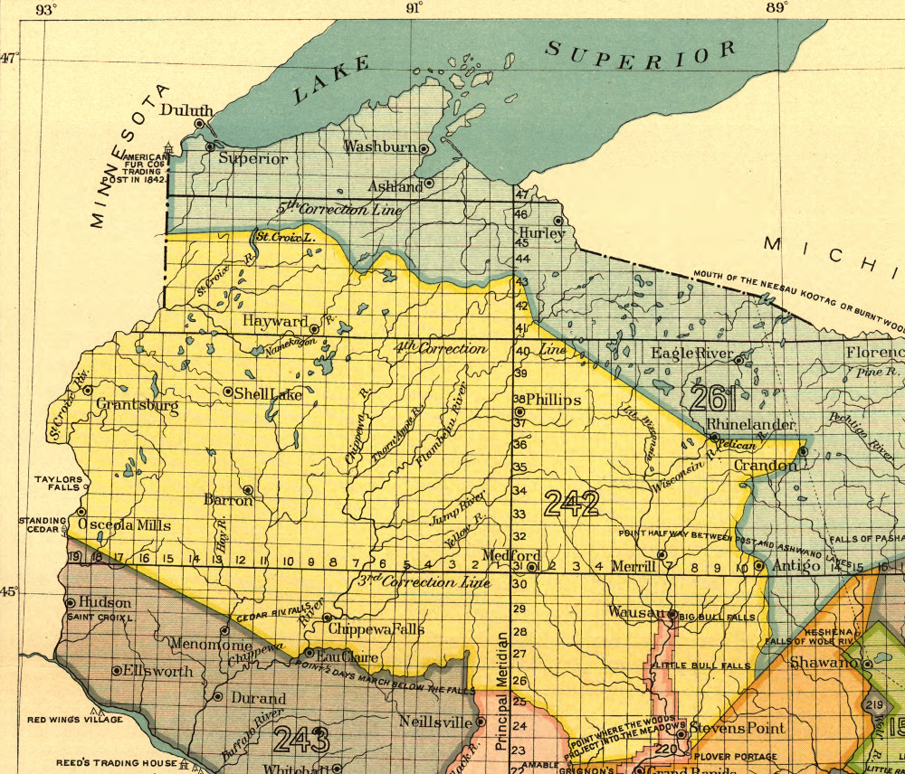
In 1847 Congress authorized funds for a geological survey of what was then called the Chippewa Land District, which encompassed approximately the northern third of modern Wisconsin, along with a section of modern Minnesota between the Mississippi River and Lake Superior. This web page is a transcription of a report from one of the field scientists, Joseph Granville Norwood MD, who had among his assignments a trip down the Wisconsin River from its source to its mouth. The expedition began at La Pointe (Madeline Island), from which they traveled south to Lac du Flambeau, east to intersect the Wisconsin River about 10 miles south of Lac Vieux Desert, and then southerly down the Wisconsin in canoes to Prairie du Chien.
The Chippewa Land District was public domain land, recently ceded to the federal government in a series of treaties, the most important being the Treaty of St. Peters (1837), named for the St. Peters River, now the Minnesota River. In 1847 much of the district remained unsurveyed – meaning the federal surveys responsible for laying out the town-range system had not been performed. There was some logging, but mostly in the form of tree poaching under the cover of dubious preemption claims. Merchants and traders operated dozens of posts, of various sizes, throughout the region. A large number of trading posts were operated by the American Fur Company, founded by John Jacob Astor.
The Ojibwe, who at the time numbered around 10,000 people, freely trapped, fished and hunted throughout the district. The reservations were not established until 1854. While the Ojibwe did live substantially on wild fish and game, by the mid-19th Ojibwe society included well-developed towns and smaller agricultural settlements. They augmented their lifestyle by trading furs, wild rice and maple sugar to merchants for guns, cloth, traps and various other assorted manufactured items. Many Ojibwe men were employed seasonally by fur traders. The Ojibwe also manufactured many (if not most) of the canoes that everyone used. As in this account, non-Indian ("white") traders and federal authorities purchased canoes from the Ojibwe.
The total number of traders, missionaries and Indians was not large and the various settlements were widely dispersed, but the activity was quite constant and movement of people and goods on the rivers and trails was steady and lively.
Treaty of St. Peters cession area. This map image is from the Library of Congress digital collections. It shows the cession area (yellow) which lies in State of Wisconsin. Another section was in Minnesota.
By 1847, the federal government, pushed by private mining interests, was anxious to establish the general mineral, timber and agricultural value of the district. In this period there was a shortage of scientifically trained personnel, which is why a medical doctor was offered the job.
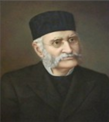
Joseph Granville Norwood was born in 1807 in rural Woodford County, Kentucky. After graduating from medical school, he was successful as a physician, but his interest in natural science led him to a career as a well-renowned geologist and paleontologist. From 1847-1851 – the important years for this report – he was Assistant U.S. Geologist for the Chippewa Land District, reporting to David Dale Owen. From 1851-58 he was state geologist of Illinois, leaving under acrimonious and politically motivated circumstances. He was immediately offered the position of assistant geologist in Missouri, and began a 25 year career on the faculty of the University of Missouri, including as the first dean of the medical school. He died in 1895. Norwood Hall at the Missouri University of Science and Technology in Rolla is named for him.
Owen was eminent in his own right. For most of his life Owen lived in New Harmony, Indiana, a colony founded by his father Robert Owen, the wealthy industrialist and social reformer. The town developed into a center for the advancement of science and education. It was also Norwood's permanent residence until he received the state geologist appointment in Illinois.
Norwood's report is published twice:
- David Dale Owen Letter of the Secretary of the Treasury, communicating a report of a geological reconnaissance of the Chippewa Land District of Wisconsin, and the northern part of Iowa (1848). Norwood's report starts page 85.
- David Dale Owen Report of a geological survey of Wisconsin, Iowa, and Minnesota; and incidentally of a portion of Nebraska Territory (1852). Norwood's report tarts page 277.
The transcription below is an amalgamation of both sources. This post-processing is necessary because there appear to be some typographical and printer mistakes, and the second version also was edited by Norwood or Owen based on fact-checking they did in the intervening four years. I have done my best to be true to the overall intent of the original reports, so that if I felt Norwood was honestly correcting himself in the second report I kept the correction rather than merely concatenating this overall transcription. There were not many instances of this.
The reader may wonder why a transcription is necessary at all, since digital scans of both sources are readily available on line. This document is much easier to read than the scanned images, and in the form of source text the document also becomes searchable and selectable. I also took the time to add explanatory maps and images, primarily to locate the account properly on modern maps and thereby give the sense, to anyone familiar with the terrain that Norwood traveled through, that his adventure was by a real person traveling through a real place.
| Part I. → |